This is a story that tends to show how little the public understands about the profession of Land Surveying.
This particular matter revolves around a misunderstanding by the public as to how record boundaries are established and perpetuated. This misunderstanding has led to statements and questions from various parties which are patently absurd but continue to be repeated.
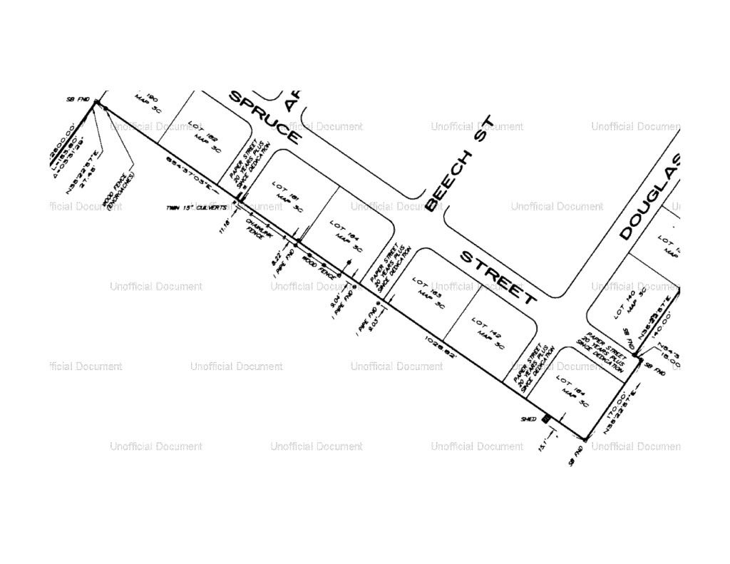
From the story in the Union Leader....
Another Spruce Street resident, Cindy Seneca, said she wants Chelsea to pay
for a survey of her property.
She said the Chelsea surveyor only made use of two markers, despite the
presence of 16 or so iron pipe boundary markers. She said the surveyor should
have measured 11 feet from the edge of the street.
Guy Praria said he ask the Chelsea's surveyor why he wasn't using the metal
pipes.
"They told us "We're doing it the way they want us to do it." Praria
said.
Later from the Naushatelegraph this comment.....
Normally the town holds an easement to the front property line and does'nt
own the 11 feet.
Above is a survey map of the situation. This survey was performed in 1996 and filed in the record. Now I don't know much about this situation but from just viewing this survey a number of things come to mind. The stone bounds (sb) shown on this map are more than likely the original monuments defining the recorded subdivision map. Subdivision maps are filed for the purpose of defining the boundaries within the subdivision by simultaneous conveyance.
The iron pipes shown on this survey which are more than 9 feet beyond the boundary of the subdivision were subsequently set (after the stone bounds) by surveyors who were apparently in error. No doubt the pipes were set to purportedly mark the boundaries of the lots within the subdivision but they failed to be set at the record location of the boundaries in question. These subsequent marks (the iron pipes) have no bearing on the record location of these lots which the surveyor is charged with locating.
The iron pipes in question may be evidence of possession and could possibly be evidence to bolster the argument that some of the owners of lots within the subdivision believed these iron pipes marked their boundary. However the surveyor has no power or authority to resolve the conflict between the record loction of the boundary and the boundary of possession. Adverse possession, acquiescence and other unwritten rights are perfected in only two ways.
1) The concerned parties all agree that the land in question is owned by one or the other and they record a document for public record acknowledging this agreement (quit claim deed, boundary line agreement, warranty deed, etc.).
2) The court awards the property to one or the other of the concerned parties as a result of legal action.
The Professional Land Surveyor has no right to adjudicate these matters nor do they have the power or authority to change the record descriptions of the properties in question to "force" the concerned parties to somehow agree on a new boundary between them.
The only competent statement I can find in this entire mess is the quotes from the lawyer in the above story. The lot owners within the subdivision may have a valid claim of adverse possession or some other legal operation suggesting they have acquired the land in dispute. But these matters are settled between the concerned parties or through legal action and are not within the preview of the Land Surveyor to grant.
The Land Surveyor in this case may have advised their client that they could lose a legal action because of the possibility that adverse possession or some other legal operation may have superseded the record boundary and created a new unwritten/unrecorded boundary. However the Land Surveyor's client is free to take any position they wish, after all they are the owners of the land in question, not the Land Surveyor.

No comments:
Post a Comment